


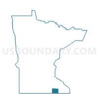
Pleasant Valley Voting District, Mower County, Minnesota
About
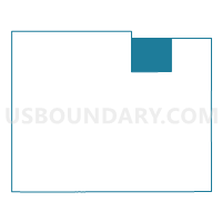
Outline

Summary
| Unique Area Identifier | 603221 |
| Name | Pleasant Valley Voting District |
| County | Mower County |
| State | Minnesota |
| Area (square miles) | 30.05 |
| Land Area (square miles) | 30.05 |
| Water Area (square miles) | 0.00 |
| % of Land Area | 100.00 |
| % of Water Area | 0.00 |
| Latitude of the Internal Point | 43.79747420 |
| Longtitude of the Internal Point | -92.62945410 |
Maps

Graphs
Select a template below for downloading or customizing gragh for Pleasant Valley Voting District, Mower County, Minnesota


Neighbors
Neighoring Voting District (by Name) Neighboring Voting District on the Map
- Dexter Twp. Voting District, Mower County, MN
- Grand Meadow Twp. Voting District, Mower County, MN
- High Forest Twp. Voting District, Olmsted County, MN
- Racine Twp. Voting District, Mower County, MN
- Sargeant Twp. Voting District, Mower County, MN
Top 10 Neighboring County Subdivision (by Population) Neighboring County Subdivision on the Map
- High Forest township, Olmsted County, MN (976)
- Racine township, Mower County, MN (455)
- Sargeant township, Mower County, MN (310)
- Dexter township, Mower County, MN (310)
- Grand Meadow township, Mower County, MN (306)
- Pleasant Valley township, Mower County, MN (304)
Top 10 Neighboring Unified School District (by Population) Neighboring Unified School District on the Map
- Stewartville Public School District, MN (8,633)
- Hayfield Public School District, MN (4,776)
- Southland Public School District, MN (3,562)
- Grand Meadow Public School District, MN (1,882)
Top 10 Neighboring State Legislative District Lower Chamber (by Population) Neighboring State Legislative District Lower Chamber on the Map
Top 10 Neighboring State Legislative District Upper Chamber (by Population) Neighboring State Legislative District Upper Chamber on the Map
Top 10 Neighboring 111th Congressional District (by Population) Neighboring 111th Congressional District on the Map
Top 10 Neighboring Census Tract (by Population) Neighboring Census Tract on the Map
- Census Tract 22, Olmsted County, MN (3,804)
- Census Tract 14, Mower County, MN (3,364)
- Census Tract 12, Mower County, MN (1,960)